Gas station nearby Valero
Coronavirus disease (COVID-19) Situation
confirmed cases
111820082
deaths
1219487
United States
Gas station nearby Valero
Valero
10 Long Island Avenue, Wyandanch Израиль
contacts phone
:
+1
Latitude:
40.7492757
, Longitude:
-73.3806741
read more
nearest Gas station
975 m
OK Petroleum
4 Colonial Springs Road, Wheatley Heights
Gas station
read more
1.429 km
H P Petro
1373 Straight Path, Wyandanch
Gas station
read more
1.514 km
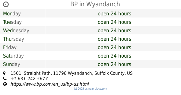
BP
1501 Straight Path, Wyandanch
Gas station
read more
1.523 km
Dave Petroleum Inc
1501 Straight Path, Wyandanch
Gas station
read more
1.687 km
OK Petroleum
1185 Straight Path, West Babylon
Gas station
read more
1.689 km
Shell
1185 Straight Path, West Babylon
Gas station
read more
1.689 km
Стрейт Пат Сервисиз
1185 Straight Path, West Babylon
Gas station
read more
1.693 km
Lukoil
1160 Straight Path, Wyandanch
Gas station
read more
1.835 km
Sunoco Gas Station
1580 Straight Path, Wyandanch
Gas station
read more
2.178 km
Mt Avenue Shell
737 Mount Avenue, West Babylon
Gas station
read more
2.341 km
S & w Auto
76 Bell Avenue # C, West Babylon
Gas station
read more
2.355 km
Север Уэлвуд Сервисиз Стейшен
1270 Wellwood Avenue, West Babylon
Gas station
read more
2.361 km
BP
1270 Wellwood Avenue, Wyandanch
Gas station
read more
2.675 km
Valero Gas
1200 Wellwood Avenue, West Babylon
Gas station
read more
2.711 km
Busy Bee Stores Corp
1200 Wellwood Avenue, Wyandanch
Gas station
read more
2.955 km
OK Petroleum
1751 Straight Path, Wyandanch
Gas station
read more
2.965 km
Arj Fuel & Oil Inc
1755 Straight Path, Dix Hills
Gas station
read more
2.966 km
Sunoco Gas Station
925 Straight Path, West Babylon
Gas station
read more
3.046 km
S & B Petroleum
725 August Road, West Babylon
Gas station
read more
3.048 km
Liberty
725 Wyandanch Avenue, North Babylon
Gas station
read more
3.237 km
Саноко Гас Стейшен
1041 Little East Neck Road, West Babylon
Gas station
read more
3.237 km
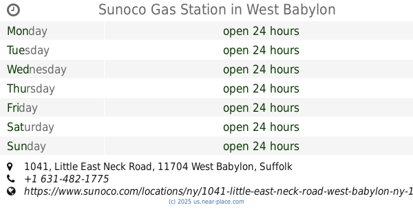
Sunoco Gas Station
1041 Little East Neck Road, West Babylon
Gas station
read more
3.505 km
Mobil
2351 New York 110, Farmingdale
Gas station
read more
4.246 km
BP
367A Sunrise Highway North Service Road, West Babylon
Gas station
read more
4.295 km
CITGO
500 New York 109, Lindenhurst
Gas station
read more
📑
all categories
Accounting
Administrative area level 1
Administrative area level 2
Airport
Amusement park
Aquarium
Art gallery
Atm
Bakery
Bank
Bar
Beauty salon
Bicycle store
Book store
Bowling alley
Bus station
Cafe
Campground
Car dealer
Car rental
Car repair
Car wash
Casino
Cemetery
Church
City hall
Clothing store
Colloquial area
Convenience store
Courthouse
Dentist
Department store
Doctor
Electrician
Electronics store
Embassy
Establishment
Finance
Fire station
Florist
Food
Funeral home
Furniture store
Gas station
General contractor
Grocery or supermarket
Gym
Hair care
Hardware store
Health
Hindu Temple
Home goods store
Hospital
Insurance agency
Intersection
Jewelry store
Laundry
Lawyer
Library
Light rail station
Liquor store
Local government office
Locality
Locksmith
Lodging
Meal delivery
Meal takeaway
Mosque
Movie rental
Movie theater
Moving company
Museum
Natural feature
Neighborhood
Night club
Painter
Park
Parking
Pet store
Pharmacy
Physiotherapist
Place of worship
Plumber
Point of interest
Police
Political
Post office
Premise
Real estate agency
Restaurant
Roofing contractor
Route
Rv park, camping
School
Shoe store
Shopping mall
Spa
Stadium
Storage
Store
Subpremise
Subway station
Supermarket
Synagogue
Taxi stand
Train station
Transit station
Travel agency
University
Veterinary care
Zoo
administrative area level 3
sublocality level 1
↑