Gas station nearby Chevron
Coronavirus disease (COVID-19) Situation
confirmed cases
111820082
deaths
1219487
United States
Gas station nearby Chevron
Chevron
808 East McKellips Road, Mesa United States
contacts phone
:
+1
Latitude:
33.4518756
, Longitude:
-111.8131888
read more
nearest Gas station
820 m
Valero
415 East McKellips Road, Mesa
Gas station
read more
1.69 km
Shell
16 West McKellips Road, Mesa
Gas station
read more
1.699 km
ARCO
25 West McKellips Road, Mesa
Gas station
read more
2.412 km
Shell
2011 East McKellips Road, Mesa
Gas station
read more
2.422 km
Mobil
1957 North Country Club Drive, Mesa
Gas station
read more
2.738 km
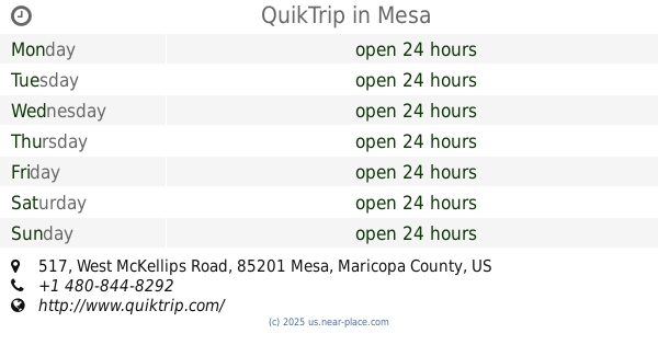
QuikTrip
517 West McKellips Road, Mesa
Gas station
read more
2.86 km
Chevron
1951 East Brown Road, Mesa
Gas station
read more
3.181 km
Shell
1601 North Beeline Highway, Scottsdale
Gas station
read more
3.391 km
Chevron Mesa
357 North Stapley Drive, Mesa
Gas station
read more
3.493 km
Fast Track Gas-N-Go
804 North Country Club Drive, Mesa
Gas station
read more
4.108 km
ARCO
406 North Country Club Drive, Mesa
Gas station
read more
4.608 km
Qt
412 North Extension Road, Mesa
Gas station
read more
4.624 km
QuikTrip
816 West University Drive, Mesa
Gas station
read more
4.949 km
Circle K
330 East Broadway Road, Mesa
Gas station
read more
4.991 km
QuikTrip
414 South Stapley Drive, Mesa
Gas station
read more
5.06 km
BP
2751 East University Drive, Mesa
Gas station
read more
5.077 km
ARCO
2751 East University Drive, Mesa
Gas station
read more
5.143 km
Shell
1158 West University Drive, Mesa
Gas station
read more
5.539 km
Main Stop Fuel And Food
2760 East Main Street, Mesa
Gas station
read more
5.869 km
Fry's Fuel Center
Mesa
Gas station
read more
5.875 km
Fry's Fuel Center
1235 West Main Street, Mesa
Gas station
read more
6.133 km
Fry's Fuel Center
2651 East Broadway Road, Mesa
Gas station
read more
6.196 km
Kroger Fuel
United States
Gas station
read more
6.36 km
$4 Car Wash
2902-2928 East Broadway Road, Mesa
Gas station
read more
6.362 km
Valero
1163 West Broadway Road, Mesa
Gas station
read more
📑
all categories
Accounting
Administrative area level 1
Administrative area level 2
Airport
Amusement park
Aquarium
Art gallery
Atm
Bakery
Bank
Bar
Beauty salon
Bicycle store
Book store
Bowling alley
Bus station
Cafe
Campground
Car dealer
Car rental
Car repair
Car wash
Casino
Cemetery
Church
City hall
Clothing store
Colloquial area
Convenience store
Courthouse
Dentist
Department store
Doctor
Electrician
Electronics store
Embassy
Establishment
Finance
Fire station
Florist
Food
Funeral home
Furniture store
Gas station
General contractor
Grocery or supermarket
Gym
Hair care
Hardware store
Health
Hindu Temple
Home goods store
Hospital
Insurance agency
Intersection
Jewelry store
Laundry
Lawyer
Library
Light rail station
Liquor store
Local government office
Locality
Locksmith
Lodging
Meal delivery
Meal takeaway
Mosque
Movie rental
Movie theater
Moving company
Museum
Natural feature
Neighborhood
Night club
Painter
Park
Parking
Pet store
Pharmacy
Physiotherapist
Place of worship
Plumber
Point of interest
Police
Political
Post office
Premise
Real estate agency
Restaurant
Roofing contractor
Route
Rv park, camping
School
Shoe store
Shopping mall
Spa
Stadium
Storage
Store
Subpremise
Subway station
Supermarket
Synagogue
Taxi stand
Train station
Transit station
Travel agency
University
Veterinary care
Zoo
administrative area level 3
sublocality level 1
↑