Food nearby Dunkin'
United States
Food nearby Dunkin'
Dunkin'
160, Adams Avenue, 11788, Hauppauge, Suffolk County, US United States
contacts phone
:
+1 631-434-9810
website:
locations.dunkindonuts.com
Latitude:
40.8114306
, Longitude:
-73.25691
larger map & directions
read more
nearest Food
805 m
Hauppauge Good Guys Taxi inc.
110 Motor Parkway, Hauppauge
Parking
Shopping mall
Health
Restaurant
Food
Point of interest
Establishment
read more
853 m
Vanity Photo Booths
99 Marcus Boulevard, Hauppauge
Food
read more
888 m
Long Island Cares Inc
10 Davids Drive, Hauppauge
Food
read more
944 m
Drl Group Ltd
49 Wireless Boulevard, Hauppauge
Food
read more
946 m
Applebee's Grill + Bar
300 Motor Parkway, Brentwood
Restaurant
Bar
Point of interest
Food
Establishment
read more
1000 m
The Gourmet Factory Inc
55 Corporate Drive, Hauppauge
Food
read more
1.042 km
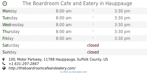
The Boardroom Cafe and Eatery
100 Motor Parkway, Hauppauge
Cafe
Store
Restaurant
Food
Point of interest
Establishment
read more
1.056 km
Wendy's
352 Motor Parkway, Hauppauge
Restaurant
Food
Point of interest
Establishment
read more
1.109 km
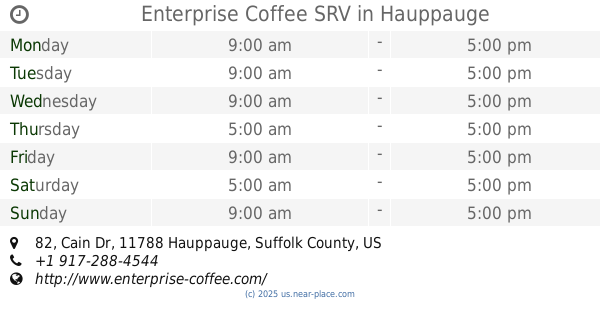
Enterprise Coffee SRV
82 Cain Dr, Hauppauge
Cafe
Food
Point of interest
Store
Establishment
read more
1.273 km
Setton International Foods Inc
85 Austin Boulevard, Commack
Food
read more
1.525 km
Fine Fare Supermarkets
126 Clarke Street, Brentwood
Supermarket
Atm
Grocery or supermarket
Finance
Food
Store
Point of interest
Establishment
read more
1.607 km
Subway
694 Motor Parkway, Hauppauge
Meal takeaway
Restaurant
Point of interest
Food
Establishment
read more
1.678 km
Chipotle Mexican Grill
694 Motor Parkway, Hauppauge
Restaurant
Point of interest
Food
Establishment
read more
1.7 km
Sempre Vivolo
696 Motor Parkway, Hauppauge
Bar
Restaurant
Food
Point of interest
Establishment
read more
2.236 km
Subway
Crabtree Commons, 1001 Crooked Hill Road, Brentwood
Meal takeaway
Restaurant
Point of interest
Food
Establishment
read more
📑
all categories
Accounting
Administrative area level 1
Administrative area level 2
Airport
Amusement park
Aquarium
Art gallery
Atm
Bakery
Bank
Bar
Beauty salon
Bicycle store
Book store
Bowling alley
Bus station
Cafe
Campground
Car dealer
Car rental
Car repair
Car wash
Casino
Cemetery
Church
City hall
Clothing store
Colloquial area
Convenience store
Courthouse
Dentist
Department store
Doctor
Electrician
Electronics store
Embassy
Establishment
Finance
Fire station
Florist
Food
Funeral home
Furniture store
Gas station
General contractor
Grocery or supermarket
Gym
Hair care
Hardware store
Health
Hindu Temple
Home goods store
Hospital
Insurance agency
Intersection
Jewelry store
Laundry
Lawyer
Library
Light rail station
Liquor store
Local government office
Locality
Locksmith
Lodging
Meal delivery
Meal takeaway
Mosque
Movie rental
Movie theater
Moving company
Museum
Natural feature
Neighborhood
Night club
Painter
Park
Parking
Pet store
Pharmacy
Physiotherapist
Place of worship
Plumber
Point of interest
Police
Political
Post office
Premise
Real estate agency
Restaurant
Roofing contractor
Route
Rv park, camping
School
Shoe store
Shopping mall
Spa
Stadium
Storage
Store
Subpremise
Subway station
Supermarket
Synagogue
Taxi stand
Train station
Transit station
Travel agency
University
Veterinary care
Zoo
administrative area level 3
sublocality level 1
↑