Convenience store nearby Rite Aid
Coronavirus disease (COVID-19) Situation
confirmed cases
111820082
deaths
1219487
United States
Convenience store nearby Rite Aid
Rite Aid
600, North Wellwood Avenue, 11757, Lindenhurst, Suffolk County, US Соединенные Штаты Америки
contacts phone
:
+1 631-226-1805
website:
locations.riteaid.com
Latitude:
40.7007389
, Longitude:
-73.3815098
larger map & directions
read more
nearest Convenience store
212 m
Sunrise Food Mart
49 Sunrise Highway, Lindenhurst
Convenience store
read more
519 m
7-Eleven
849 North Greene Avenue, Lindenhurst
Convenience store
read more
547 m
The Barn
691 Wellwood Avenue # 1, Lindenhurst
Convenience store
read more
597 m
7-Eleven
52 E Sunrise Hwy, Lindenhurst
Convenience store
read more
687 m
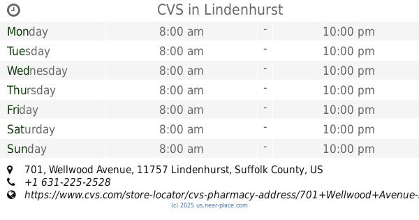
CVS
701 Wellwood Avenue, Lindenhurst
Convenience store
read more
992 m
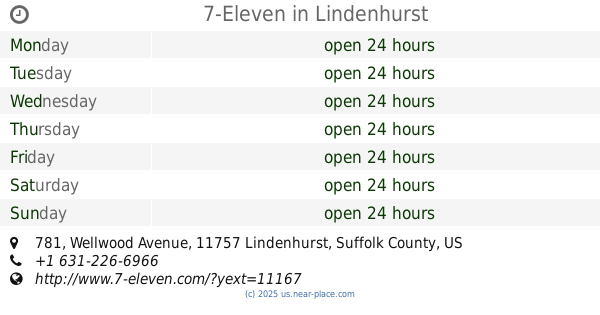
7-Eleven
781 Wellwood Avenue, Lindenhurst
Convenience store
read more
1.191 km
35th Street Family Deli Inc
302 35th Street, Lindenhurst
Convenience store
read more
1.193 km
7-Eleven
175 West Sunrise Highway, Lindenhurst
Convenience store
read more
1.455 km
7-Eleven
540 New York 109, Lindenhurst
Convenience store
read more
1.469 km
Bakkal Food
656 New York 109, Lindenhurst
Convenience store
read more
1.501 km
Midland Mini Mart & Gas
500 New York 109, Lindenhurst
Convenience store
read more
1.501 km
Мидленд Мини Март & Гас
500 New York 109, Lindenhurst
Convenience store
read more
1.501 km
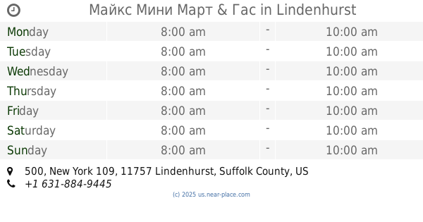
Майкс Мини Март & Гас
500 New York 109, Lindenhurst
Convenience store
read more
1.583 km
Erkan Petroleum Inc
West Babylon
Convenience store
read more
1.618 km
Cuzins Smoke Shop
117 North Wellwood Avenue, Lindenhurst
Convenience store
read more
1.641 km
Coup Enterprises Inc
1201 Sunrise Highway, Copiague
Convenience store
read more
1.888 km
Quick Mart
1014 New York 109, Lindenhurst
Convenience store
read more
1.912 km
7-Eleven
1000 Wellwood Avenue, West Babylon
Convenience store
read more
2.038 km
7-Eleven
295 South Wellwood Avenue, Lindenhurst
Convenience store
read more
2.502 km
Speedy Mart
2225 Great Neck Road, Copiague
Convenience store
read more
2.834 km
CVS
20 E Montauk Highway, Lindenhurst
Convenience store
read more
2.912 km
Speedway
274 Montauk Highway, Lindenhurst
Convenience store
read more
3.042 km
GMT Dairy Products Inc
187 Florida Street, Farmingdale
Convenience store
read more
3.047 km
7-Eleven
901 Little East Neck Road, West Babylon
Convenience store
read more
3.617 km
One Stop Corner
293 Broadway, Amityville
Convenience store
read more
📑
all categories
Accounting
Administrative area level 1
Administrative area level 2
Airport
Amusement park
Aquarium
Art gallery
Atm
Bakery
Bank
Bar
Beauty salon
Bicycle store
Book store
Bowling alley
Bus station
Cafe
Campground
Car dealer
Car rental
Car repair
Car wash
Casino
Cemetery
Church
City hall
Clothing store
Colloquial area
Convenience store
Courthouse
Dentist
Department store
Doctor
Electrician
Electronics store
Embassy
Establishment
Finance
Fire station
Florist
Food
Funeral home
Furniture store
Gas station
General contractor
Grocery or supermarket
Gym
Hair care
Hardware store
Health
Hindu Temple
Home goods store
Hospital
Insurance agency
Intersection
Jewelry store
Laundry
Lawyer
Library
Light rail station
Liquor store
Local government office
Locality
Locksmith
Lodging
Meal delivery
Meal takeaway
Mosque
Movie rental
Movie theater
Moving company
Museum
Natural feature
Neighborhood
Night club
Painter
Park
Parking
Pet store
Pharmacy
Physiotherapist
Place of worship
Plumber
Point of interest
Police
Political
Post office
Premise
Real estate agency
Restaurant
Roofing contractor
Route
Rv park, camping
School
Shoe store
Shopping mall
Spa
Stadium
Storage
Store
Subpremise
Subway station
Supermarket
Synagogue
Taxi stand
Train station
Transit station
Travel agency
University
Veterinary care
Zoo
administrative area level 3
sublocality level 1
↑