Convenience store nearby 4th Street Market
United States
Convenience store nearby 4th Street Market
4th Street Market
307 4th Street, Bakersfield United States
contacts phone
:
+1
Latitude:
35.3605895
, Longitude:
-119.0054836
read more
nearest Convenience store
176 m
One Stop
349 Union Avenue, Bakersfield
Convenience store
read more
200 m
Quik Shop Mini Mart
Bakersfield
Convenience store
read more
1.024 km
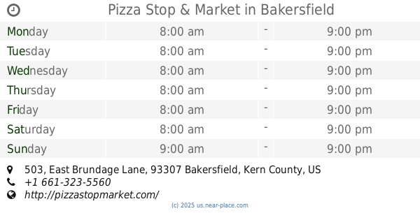
Pizza Stop & Market
503 East Brundage Lane, Bakersfield
Convenience store
Meal takeaway
Restaurant
Food
Point of interest
Store
Establishment
read more
1.261 km
Day & Night Market
355 Chester Avenue, Bakersfield
Convenience store
read more
1.285 km
Mini Dollar World
1200 California Avenue, Bakersfield
Convenience store
read more
1.322 km
Big Apple Tobacco & Discount
801 Chester Avenue, Bakersfield
Convenience store
read more
1.661 km
ampm
1701 Brundage Lane, Bakersfield
Convenience store
read more
2.044 km
Olive Town Center LLC
1401 19th Street #400, Bakersfield
Convenience store
read more
2.181 km
7-Eleven
2331 Chester Lane, Bakersfield
Convenience store
read more
2.448 km
Downtown Shell
2317 L Street, Bakersfield
Gas station
Convenience store
Cafe
Liquor store
Food
Store
Point of interest
Establishment
read more
2.509 km
Rite Aid
1601 23rd Street, Bakersfield
Convenience store
read more
2.648 km
Snappy Food Store
1700 South Chester Avenue, Bakersfield
Convenience store
Atm
Finance
Food
Store
Point of interest
Establishment
read more
2.746 km
ampm
900 Monterey Street, Bakersfield
Convenience store
Atm
Finance
Food
Store
Point of interest
Establishment
read more
2.753 km
ampm
3829, 2301 F Street, Bakersfield
Convenience store
read more
3.088 km
ampm
3125 California Avenue, Bakersfield
Convenience store
Atm
Finance
Store
Food
Point of interest
Establishment
read more
📑
all categories
Accounting
Administrative area level 1
Administrative area level 2
Airport
Amusement park
Aquarium
Art gallery
Atm
Bakery
Bank
Bar
Beauty salon
Bicycle store
Book store
Bowling alley
Bus station
Cafe
Campground
Car dealer
Car rental
Car repair
Car wash
Casino
Cemetery
Church
City hall
Clothing store
Colloquial area
Convenience store
Courthouse
Dentist
Department store
Doctor
Electrician
Electronics store
Embassy
Establishment
Finance
Fire station
Florist
Food
Funeral home
Furniture store
Gas station
General contractor
Grocery or supermarket
Gym
Hair care
Hardware store
Health
Hindu Temple
Home goods store
Hospital
Insurance agency
Intersection
Jewelry store
Laundry
Lawyer
Library
Light rail station
Liquor store
Local government office
Locality
Locksmith
Lodging
Meal delivery
Meal takeaway
Mosque
Movie rental
Movie theater
Moving company
Museum
Natural feature
Neighborhood
Night club
Painter
Park
Parking
Pet store
Pharmacy
Physiotherapist
Place of worship
Plumber
Point of interest
Police
Political
Post office
Premise
Real estate agency
Restaurant
Roofing contractor
Route
Rv park, camping
School
Shoe store
Shopping mall
Spa
Stadium
Storage
Store
Subpremise
Subway station
Supermarket
Synagogue
Taxi stand
Train station
Transit station
Travel agency
University
Veterinary care
Zoo
administrative area level 3
sublocality level 1
↑