Cafe nearby 24th Street Cafe
United States
Cafe nearby 24th Street Cafe
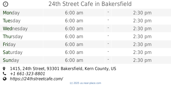
24th Street Cafe
1415 24th St, Bakersfield United States
contacts phone
:
+1
Latitude:
35.3808044
, Longitude:
-119.0180549
read more
nearest Cafe
2 m
24th Street Cafe
1415 24th Street, Bakersfield
Cafe
Restaurant
Food
Point of interest
Establishment
read more
119 m
Downtown Shell
2317 L Street, Bakersfield
Gas station
Convenience store
Cafe
Liquor store
Food
Store
Point of interest
Establishment
read more
171 m
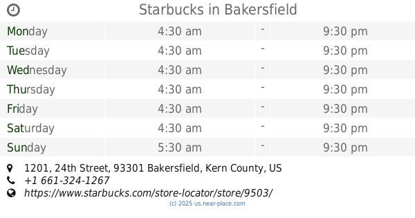
Starbucks
1201 24th Street, Bakersfield
Cafe
Store
Restaurant
Food
Point of interest
Establishment
read more
357 m
Starbucks
2615 Chester Avenue, Bakersfield
Cafe
Food
Store
Point of interest
Establishment
read more
421 m
Dunkin'
1800 23rd Street D, Bakersfield
Meal takeaway
Bakery
Cafe
Store
Restaurant
Food
Point of interest
Establishment
read more
435 m
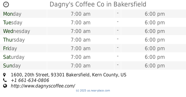
Dagny's Coffee Co
1600 20th Street #3902, Bakersfield
Bakery
Cafe
Store
Restaurant
Food
Point of interest
Establishment
read more
458 m
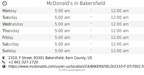
McDonald's
2310 F Street, Bakersfield
Cafe
Store
Restaurant
Food
Point of interest
Establishment
read more
518 m
Tina Marie's
1534 19th Street, Bakersfield
Cafe
Food
Point of interest
Establishment
read more
583 m
Bonnie's Best Cafe
1900 21st Street, Bakersfield
Cafe
Restaurant
Food
Point of interest
Establishment
read more
598 m
The 18hundred
1800 Chester Avenue, Bakersfield
Restaurant
Cafe
Food
Store
Point of interest
Establishment
read more
650 m
Sequoia Sandwich Company
1231 18th Street, Bakersfield
Cafe
read more
656 m
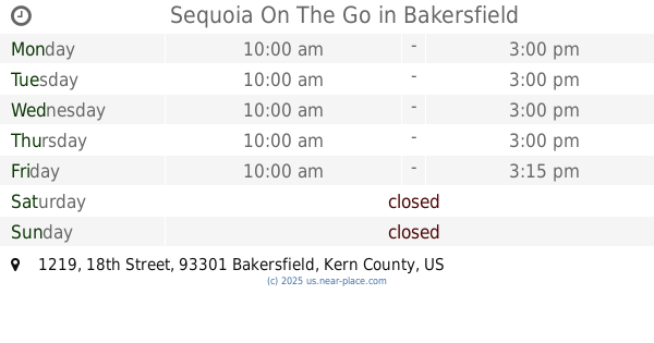
Sequoia On The Go
1219 18th Street, Bakersfield
Cafe
Food
Point of interest
Establishment
read more
750 m
Mossman's Westchester Coffee Shop
1819 30th Street, Bakersfield
Cafe
Store
Restaurant
Food
Point of interest
Establishment
read more
801 m
Adventure Awaits Coffee Shop
819 19th Street, Bakersfield
Cafe
Store
Food
Point of interest
Establishment
read more
868 m
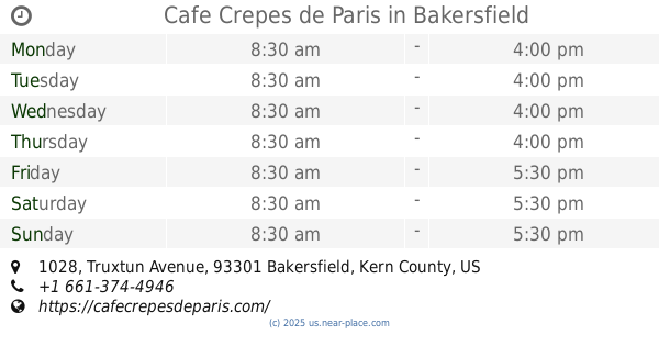
Cafe Crepes de Paris
1028 Truxtun Avenue, Bakersfield
Cafe
Restaurant
Food
Store
Point of interest
Establishment
read more
📑
all categories
Accounting
Administrative area level 1
Administrative area level 2
Airport
Amusement park
Aquarium
Art gallery
Atm
Bakery
Bank
Bar
Beauty salon
Bicycle store
Book store
Bowling alley
Bus station
Cafe
Campground
Car dealer
Car rental
Car repair
Car wash
Casino
Cemetery
Church
City hall
Clothing store
Colloquial area
Convenience store
Courthouse
Dentist
Department store
Doctor
Electrician
Electronics store
Embassy
Establishment
Finance
Fire station
Florist
Food
Funeral home
Furniture store
Gas station
General contractor
Grocery or supermarket
Gym
Hair care
Hardware store
Health
Hindu Temple
Home goods store
Hospital
Insurance agency
Intersection
Jewelry store
Laundry
Lawyer
Library
Light rail station
Liquor store
Local government office
Locality
Locksmith
Lodging
Meal delivery
Meal takeaway
Mosque
Movie rental
Movie theater
Moving company
Museum
Natural feature
Neighborhood
Night club
Painter
Park
Parking
Pet store
Pharmacy
Physiotherapist
Place of worship
Plumber
Point of interest
Police
Political
Post office
Premise
Real estate agency
Restaurant
Roofing contractor
Route
Rv park, camping
School
Shoe store
Shopping mall
Spa
Stadium
Storage
Store
Subpremise
Subway station
Supermarket
Synagogue
Taxi stand
Train station
Transit station
Travel agency
University
Veterinary care
Zoo
administrative area level 3
sublocality level 1
↑