Bus station nearby Perry St & 3rd St
Coronavirus disease (COVID-19) Situation
confirmed cases
111820082
deaths
1219487
United States
Bus station nearby Perry St & 3rd St
Perry St & 3rd St
San Francisco, CA 94107, USA
contacts phone
:
+1
Latitude:
37.7819606
, Longitude:
-122.3970359
larger map & directions
read more
nearest Bus station
42 m
3rd St & Perry St
San Francisco
Bus station
read more
77 m
Harrison St & 3rd St
United States
Bus station
read more
296 m
2nd St & Harrison St
United States
Bus station
read more
302 m
Bryant St & 4th St
United States
Bus station
read more
430 m
Folsom St & 2nd St
San Francisco
Bus station
read more
448 m
2nd St & Brannan St
United States
Bus station
read more
514 m
Bryant St & 5th St
United States
Bus station
read more
565 m
4th St & Townsend St
United States
Bus station
read more
618 m
Townsend St & 5th St
United States
Bus station
read more
708 m
King St & 2nd St
United States
Bus station
read more
804 m
6th St & Bryant St
United States
Bus station
read more
820 m
6th St & Harrison St
San Francisco
Bus station
read more
855 m
Howard St & Fremont St
United States
Bus station
read more
899 m
Kearny St & Geary St
United States
Bus station
read more
912 m
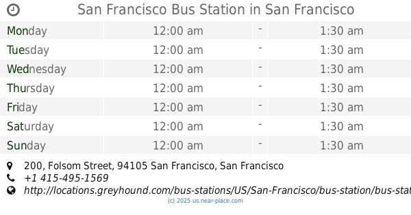
San Francisco Bus Station
200 Folsom Street, San Francisco
Bus station
read more
921 m
Market St & 4th St
835 Market St, San Francisco
Bus station
read more
924 m
Transbay Temp Terminal
United States
Bus station
read more
946 m
Market St & Sansome St
United States
Bus station
read more
957 m
Salesforce Transit Center
United States
Bus station
read more
1.011 km
Sansome St & Sutter St
San Francisco
Bus station
read more
1.032 km
Cyril Magnin St & Market St
United States
Bus station
read more
1.041 km
Kearny St & Sutter St
United States
Bus station
read more
1.075 km
Post St & Grant Ave
United States
Bus station
read more
1.116 km
Harrison St & 7th St
United States
Bus station
read more
1.14 km
Folsom St & 7th St
United States
Bus station
read more
📑
all categories
Accounting
Administrative area level 1
Administrative area level 2
Airport
Amusement park
Aquarium
Art gallery
Atm
Bakery
Bank
Bar
Beauty salon
Bicycle store
Book store
Bowling alley
Bus station
Cafe
Campground
Car dealer
Car rental
Car repair
Car wash
Casino
Cemetery
Church
City hall
Clothing store
Colloquial area
Convenience store
Courthouse
Dentist
Department store
Doctor
Electrician
Electronics store
Embassy
Establishment
Finance
Fire station
Florist
Food
Funeral home
Furniture store
Gas station
General contractor
Grocery or supermarket
Gym
Hair care
Hardware store
Health
Hindu Temple
Home goods store
Hospital
Insurance agency
Intersection
Jewelry store
Laundry
Lawyer
Library
Light rail station
Liquor store
Local government office
Locality
Locksmith
Lodging
Meal delivery
Meal takeaway
Mosque
Movie rental
Movie theater
Moving company
Museum
Natural feature
Neighborhood
Night club
Painter
Park
Parking
Pet store
Pharmacy
Physiotherapist
Place of worship
Plumber
Point of interest
Police
Political
Post office
Premise
Real estate agency
Restaurant
Roofing contractor
Route
Rv park, camping
School
Shoe store
Shopping mall
Spa
Stadium
Storage
Store
Subpremise
Subway station
Supermarket
Synagogue
Taxi stand
Train station
Transit station
Travel agency
University
Veterinary care
Zoo
administrative area level 3
sublocality level 1
↑