Bar nearby WXOU Bar
Coronavirus disease (COVID-19) Situation
confirmed cases
111820082
deaths
1219487
United States
Bar nearby WXOU Bar
WXOU Bar
558, Hudson Street, 10014, New York, New York County, US Соединенные Штаты Америки
contacts phone
:
+1
Latitude:
40.735424
, Longitude:
-74.0057815
larger map & directions
read more
nearest Bar
44 m
White Horse Tavern
567 Hudson Street, New York
Bar
read more
85 m
Aria West Village
117 Perry Street, New York
Bar
read more
149 m
Decoy
downstairs, 529-1/2 Hudson Street, New York
Bar
read more
223 m
Extra Virgin
259 West 4th Street, New York
Bar
read more
287 m
Fat Cat
75 Christopher Street, New York
Bar
read more
301 m
Cubbyhole
281 West 12th Street A, New York
Bar
read more
423 m
The Spaniard
190 West 4th Street, New York
Bar
read more
605 m
Neta
61 West 8th Street, New York
Bar
read more
613 m
Valbella
421 West 13th Street, New York
Bar
read more
657 m
3 Sheets Saloon
1209, 134 West 3rd Street, New York
Bar
read more
752 m
Giovanni Rana Pastificio & Cucina
75 9th Avenue, New York
Bar
read more
824 m
Triona's
237 Sullivan Street, New York
Bar
read more
825 m
Thai Sliders
150 8th Avenue, New York
Bar
read more
830 m
Hello Saigon
180 Bleecker Street, New York
Bar
read more
837 m
Flight 151
151 8th Avenue, New York
Bar
read more
837 m
Villa Mosconi
69 Macdougal Street, New York
Bar
read more
858 m
Zinc Bar
82 West 3rd Street, New York
Bar
read more
865 m
Amity Hall
80 West 3rd Street, New York
Bar
read more
881 m
Kap Salon Aalst
12345 North St, New York
Bar
read more
889 m
Charlie Bird
5 King Street, New York
Bar
read more
895 m
Toro
85 10th Avenue, New York
Bar
read more
938 m
The Red Lion
151 Bleecker Street, New York
Bar
read more
991 m
Peter McManus Cafe
152 7th Ave, New York
Bar
read more
1.03 km
The Folly
92 West Houston Street, New York
Bar
read more
1.075 km
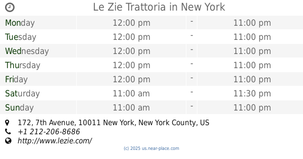
Le Zie Trattoria
172 7th Avenue, New York
Bar
read more
📑
all categories
Accounting
Administrative area level 1
Administrative area level 2
Airport
Amusement park
Aquarium
Art gallery
Atm
Bakery
Bank
Bar
Beauty salon
Bicycle store
Book store
Bowling alley
Bus station
Cafe
Campground
Car dealer
Car rental
Car repair
Car wash
Casino
Cemetery
Church
City hall
Clothing store
Colloquial area
Convenience store
Courthouse
Dentist
Department store
Doctor
Electrician
Electronics store
Embassy
Establishment
Finance
Fire station
Florist
Food
Funeral home
Furniture store
Gas station
General contractor
Grocery or supermarket
Gym
Hair care
Hardware store
Health
Hindu Temple
Home goods store
Hospital
Insurance agency
Intersection
Jewelry store
Laundry
Lawyer
Library
Light rail station
Liquor store
Local government office
Locality
Locksmith
Lodging
Meal delivery
Meal takeaway
Mosque
Movie rental
Movie theater
Moving company
Museum
Natural feature
Neighborhood
Night club
Painter
Park
Parking
Pet store
Pharmacy
Physiotherapist
Place of worship
Plumber
Point of interest
Police
Political
Post office
Premise
Real estate agency
Restaurant
Roofing contractor
Route
Rv park, camping
School
Shoe store
Shopping mall
Spa
Stadium
Storage
Store
Subpremise
Subway station
Supermarket
Synagogue
Taxi stand
Train station
Transit station
Travel agency
University
Veterinary care
Zoo
administrative area level 3
sublocality level 1
↑