Bar nearby The New Potato
Coronavirus disease (COVID-19) Situation
confirmed cases
111820082
deaths
1219487
United States
Bar nearby The New Potato
The New Potato
3519 Clinton Drive, Houston United States
contacts phone
:
+1
Latitude:
29.764982
, Longitude:
-95.3338739
read more
nearest Bar
1.48 km
Black Barbie
135 North Everton Street, Houston
Bar
read more
1.624 km
Saint Bernard's Pub
1901, 3907 Canal Street, Houston
Bar
read more
1.732 km
Houston downtown
805 Hardy Street, Houston
Bar
read more
1.83 km
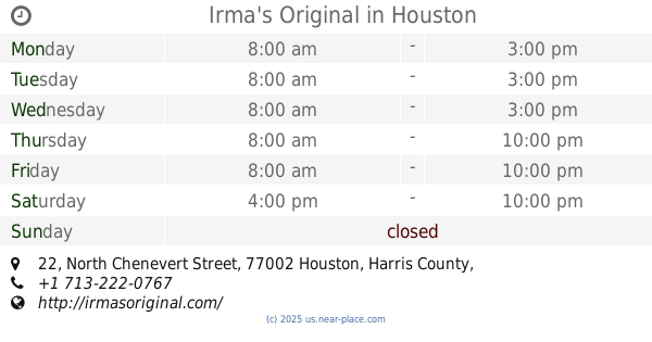
Irma's Original
22 North Chenevert Street, Houston
Bar
read more
1.864 km
Elanbie Te
300-398 Lockwood Drive, Houston
Bar
read more
1.897 km
Last Concert Cafe
1403 Nance Street, Houston
Bar
read more
1.979 km
Voodoo Queen
322 Milby Street, Houston
Bar
read more
1.984 km
Cat travis
2000 Congress Avenue, Houston
Bar
read more
2.17 km
El Parque
Houston
Bar
read more
2.218 km
Top Shelf
5101 Avenue H, Houston
Bar
read more
2.219 km
Texas Bar
2200 Texas Street, Houston
Bar
read more
2.312 km
Cross Bar
2200 Texas Street, Houston
Bar
read more
2.345 km
Heineken Star Bar
BBVA Compass Stadium, Heineken Terrace, Houston
Bar
read more
2.369 km
Pitch Pub
Houston
Bar
read more
2.418 km
Lucky's Pub
801 Saint Emanuel Street, Houston
Bar
read more
2.47 km
King's Court Bar and Kitchen
903 Hutchins Street, Houston
Bar
read more
2.498 km
Pitch 25
2120 Walker Street, Houston
Bar
read more
2.515 km
The Cottonmouth Club
108 South Main Street, Houston
Bar
read more
2.529 km
Neil's Bahr
2006 Walker Street, Houston
Bar
read more
2.536 km
Iron and Oak
208 Travis Street, Houston
Bar
read more
2.586 km
Houston Watch Company
913 Franklin Street, Houston
Bar
read more
2.602 km
El Barretal Sports Bar
2341 Elysian Street, Houston
Bar
read more
2.642 km
Public Services Wine & Whisky
202 Travis Street #100, Houston
Bar
read more
2.664 km
Okra - Charity Bar
924 Congress Avenue, Houston
Bar
read more
3.428 km
Isles Eatery and Rum Bar
1515 Pease Street, Houston
Bar
read more
📑
all categories
Accounting
Administrative area level 1
Administrative area level 2
Airport
Amusement park
Aquarium
Art gallery
Atm
Bakery
Bank
Bar
Beauty salon
Bicycle store
Book store
Bowling alley
Bus station
Cafe
Campground
Car dealer
Car rental
Car repair
Car wash
Casino
Cemetery
Church
City hall
Clothing store
Colloquial area
Convenience store
Courthouse
Dentist
Department store
Doctor
Electrician
Electronics store
Embassy
Establishment
Finance
Fire station
Florist
Food
Funeral home
Furniture store
Gas station
General contractor
Grocery or supermarket
Gym
Hair care
Hardware store
Health
Hindu Temple
Home goods store
Hospital
Insurance agency
Intersection
Jewelry store
Laundry
Lawyer
Library
Light rail station
Liquor store
Local government office
Locality
Locksmith
Lodging
Meal delivery
Meal takeaway
Mosque
Movie rental
Movie theater
Moving company
Museum
Natural feature
Neighborhood
Night club
Painter
Park
Parking
Pet store
Pharmacy
Physiotherapist
Place of worship
Plumber
Point of interest
Police
Political
Post office
Premise
Real estate agency
Restaurant
Roofing contractor
Route
Rv park, camping
School
Shoe store
Shopping mall
Spa
Stadium
Storage
Store
Subpremise
Subway station
Supermarket
Synagogue
Taxi stand
Train station
Transit station
Travel agency
University
Veterinary care
Zoo
administrative area level 3
sublocality level 1
↑