Bar nearby Otway
United States
Bar nearby Otway
Otway
930, Fulton Street, 11238, Kings County, New York, US Соединенные Штаты Америки
contacts phone
:
+1 917-909-1889
website:
otwaynyc.com
Latitude:
40.6826628
, Longitude:
-73.9637644
larger map & directions
read more
nearest Bar
165 m
Hops Hill
886 Fulton Street, Brooklyn
Bar
read more
226 m
Hanson Dry
925 Fulton Street, Brooklyn
Bar
read more
520 m
Branded Saloon
603 Vanderbilt Avenue, Brooklyn
Bar
read more
637 m
Tiptop Bar & Grill
432 Franklin Avenue, New York
Bar
read more
659 m
Dean Cafe Bar
951 Dean Street, Brooklyn
Bar
read more
755 m
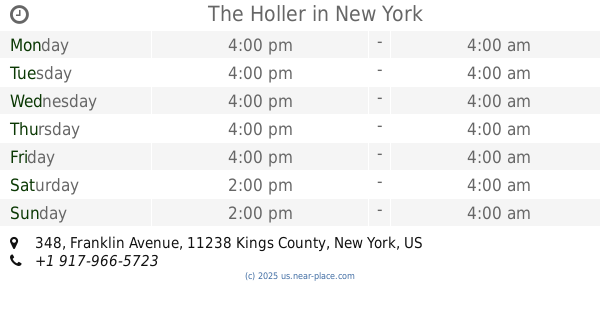
The Holler
348 Franklin Avenue, Brooklyn
Bar
read more
808 m
Half Court Sports Bar
446 Park Place, Brooklyn
Bar
read more
873 m
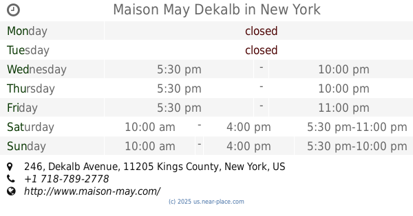
Maison May Dekalb
246 Dekalb Avenue, Brooklyn
Bar
read more
881 m
Covenhoven
730 Classon Avenue, Brooklyn
Bar
read more
974 m
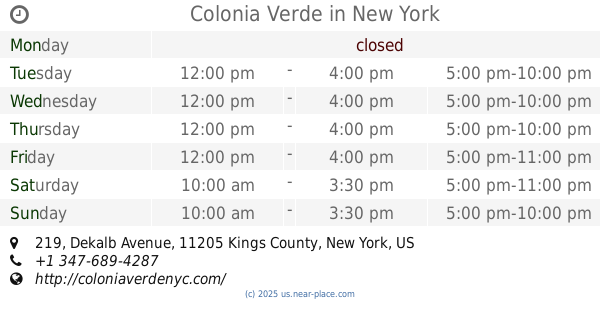
Colonia Verde
219 Dekalb Avenue, Brooklyn
Bar
read more
976 m
KuyaBar
455 Dekalb Avenue, Brooklyn
Bar
read more
984 m
nzuri lounge
1200 Fulton Street, New York
Bar
read more
1.014 km
Black Swan
1048 Bedford Avenue, New York
Bar
read more
1.02 km
Latino Sports Club
665 Franklin Avenue, Brooklyn
Bar
read more
1.093 km
The Smoke Joint
87 South Elliott Place, Brooklyn
Bar
read more
📑
all categories
Accounting
Administrative area level 1
Administrative area level 2
Airport
Amusement park
Aquarium
Art gallery
Atm
Bakery
Bank
Bar
Beauty salon
Bicycle store
Book store
Bowling alley
Bus station
Cafe
Campground
Car dealer
Car rental
Car repair
Car wash
Casino
Cemetery
Church
City hall
Clothing store
Colloquial area
Convenience store
Courthouse
Dentist
Department store
Doctor
Electrician
Electronics store
Embassy
Establishment
Finance
Fire station
Florist
Food
Funeral home
Furniture store
Gas station
General contractor
Grocery or supermarket
Gym
Hair care
Hardware store
Health
Hindu Temple
Home goods store
Hospital
Insurance agency
Intersection
Jewelry store
Laundry
Lawyer
Library
Light rail station
Liquor store
Local government office
Locality
Locksmith
Lodging
Meal delivery
Meal takeaway
Mosque
Movie rental
Movie theater
Moving company
Museum
Natural feature
Neighborhood
Night club
Painter
Park
Parking
Pet store
Pharmacy
Physiotherapist
Place of worship
Plumber
Point of interest
Police
Political
Post office
Premise
Real estate agency
Restaurant
Roofing contractor
Route
Rv park, camping
School
Shoe store
Shopping mall
Spa
Stadium
Storage
Store
Subpremise
Subway station
Supermarket
Synagogue
Taxi stand
Train station
Transit station
Travel agency
University
Veterinary care
Zoo
administrative area level 3
sublocality level 1
↑