Bar nearby Mission Dolores
Coronavirus disease (COVID-19) Situation
confirmed cases
111820082
deaths
1219487
United States
Bar nearby Mission Dolores
Mission Dolores
249, 4th Avenue, 11215, Kings County, New York, US United States
contacts phone
:
+1 347-457-5606
website:
www.missiondolores.com
Latitude:
40.6761867
, Longitude:
-73.9834314
larger map & directions
read more
nearest Bar
225 m
Lucky 13 Saloon
644 Sackett Street, Brooklyn
Bar
read more
233 m
The Commissioner
247 5th Avenue, Brooklyn
Bar
read more
248 m
Brooklyn Burgers & Beer
259 5th Avenue, Brooklyn
Bar
read more
280 m
Warefarm LLC
702 Union Street, Brooklyn
Bar
read more
371 m
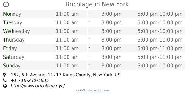
Bricolage
162 5th Avenue, Brooklyn
Bar
read more
397 m
Nana Restaurant & Bar
155 5th Avenue, Brooklyn
Bar
read more
470 m
Mulino
133 5th Avenue, Brooklyn
Bar
read more
572 m
Logan's Run
375 5th Avenue A, Brooklyn
Bar
read more
683 m
Bison & Bourbon
191 7th St, Brooklyn
Bar
read more
700 m
Faros
84 7th Avenue, Brooklyn
Bar
read more
713 m
Pacific Standard
82 4th Avenue, Brooklyn
Bar
read more
752 m
Wyckoff
280 Wyckoff Street, Brooklyn
Bar
read more
772 m
Alchemy
56 5th Avenue, Brooklyn
Bar
read more
782 m
The Owl Farm
297 9th Street, Brooklyn
Bar
read more
783 m
Shinju II Sushi
236 7th Avenue, Brooklyn
Bar
read more
799 m
Parish Cocktail Bar
3005, 223 7th Avenue, Brooklyn
Bar
read more
859 m
Mokbar BK
212 Flatbush Avenue, Brooklyn
Bar
read more
859 m
Black Mountain Wine House
415 Union Street, Brooklyn
Bar
read more
887 m
Morgan’s Barbecue
267 Flatbush Avenue, Brooklyn
Bar
read more
979 m
Franny's
348 Flatbush Avenue, Brooklyn
Bar
read more
995 m
40/40 Club
620 Atlantic Avenue, Brooklyn
Bar
read more
1.002 km
The Monro Pub
481 5th Avenue, Brooklyn
Bar
read more
1.053 km
Bar San Miguel
307 Smith Street, Brooklyn
Bar
read more
1.097 km
Barely Disfigured
257 Smith Street, Brooklyn
Bar
read more
1.188 km
Clover Club
210 Smith Street, Brooklyn
Bar
read more
📑
all categories
Accounting
Administrative area level 1
Administrative area level 2
Airport
Amusement park
Aquarium
Art gallery
Atm
Bakery
Bank
Bar
Beauty salon
Bicycle store
Book store
Bowling alley
Bus station
Cafe
Campground
Car dealer
Car rental
Car repair
Car wash
Casino
Cemetery
Church
City hall
Clothing store
Colloquial area
Convenience store
Courthouse
Dentist
Department store
Doctor
Electrician
Electronics store
Embassy
Establishment
Finance
Fire station
Florist
Food
Funeral home
Furniture store
Gas station
General contractor
Grocery or supermarket
Gym
Hair care
Hardware store
Health
Hindu Temple
Home goods store
Hospital
Insurance agency
Intersection
Jewelry store
Laundry
Lawyer
Library
Light rail station
Liquor store
Local government office
Locality
Locksmith
Lodging
Meal delivery
Meal takeaway
Mosque
Movie rental
Movie theater
Moving company
Museum
Natural feature
Neighborhood
Night club
Painter
Park
Parking
Pet store
Pharmacy
Physiotherapist
Place of worship
Plumber
Point of interest
Police
Political
Post office
Premise
Real estate agency
Restaurant
Roofing contractor
Route
Rv park, camping
School
Shoe store
Shopping mall
Spa
Stadium
Storage
Store
Subpremise
Subway station
Supermarket
Synagogue
Taxi stand
Train station
Transit station
Travel agency
University
Veterinary care
Zoo
administrative area level 3
sublocality level 1
↑