Bar nearby Mamajuana Cafe Queens
Coronavirus disease (COVID-19) Situation
confirmed cases
111820082
deaths
1219487
United States
Bar nearby Mamajuana Cafe Queens
Mamajuana Cafe Queens
33-15 56th Street, Woodside Израиль
contacts phone
:
+1
Latitude:
40.7527664
, Longitude:
-73.9049814
read more
nearest Bar
131 m
Bohemia Lounge
54-11 Northern Boulevard, Woodside
Bar
read more
575 m
Smoke & Spice
30-86 51st Street, Woodside
Bar
read more
709 m
Billar
69-10 34th Avenue, Woodside
Bar
read more
751 m
Natalia's Bar
6210 39th Avenue, Flushing
Bar
read more
751 m
BQE Billiards & Bar
70-02 34th Avenue, Jackson Heights
Bar
read more
773 m
Station Bar
39-50 61st Street, Woodside
Bar
read more
779 m
El Abuelo Pachanguero
39-08 63rd Street, Flushing
Bar
read more
795 m
The Beerkeeper
58-15 Woodside Avenue, Woodside
Bar
read more
835 m
The Brewery Bar & Kitchen
49-18 30th Avenue, Woodside
Bar
read more
849 m
Donovan's Pub
57-24 Roosevelt Avenue, Woodside
Bar
read more
865 m
La Fonda Bar
64-09 Roosevelt Avenue, Woodside
Bar
read more
873 m
Sean Og's
60-02 Woodside Avenue, Woodside
Bar
read more
913 m
Cuckoo's Nest
6104 Woodside Avenue, Flushing
Bar
read more
951 m
The Shillelagh Tavern
47-22 30th Avenue, Long Island City
Bar
read more
979 m
Maguire's Public House
54-20 Roosevelt Avenue, Flushing
Bar
read more
999 m
Tres Coronas
53-23 Roosevelt Avenue, Flushing
Bar
read more
1.009 km
Rudar Club
34-01 45th Street, Astoria
Bar
read more
1.038 km
Dillingers Pub & Grill
4619 30th Ave, Astoria
Bar
read more
1.051 km
Weekender
41-46 54th Street, Woodside
Bar
read more
1.059 km
Scorpion Bar
6908 Roosevelt Avenue, Jackson Heights
Bar
read more
1.08 km
Chulitas
6916 Roosevelt Avenue, Woodside
Bar
read more
1.105 km
The Globe Tavern
4910 Skillman Avenue, Flushing
Bar
read more
1.147 km
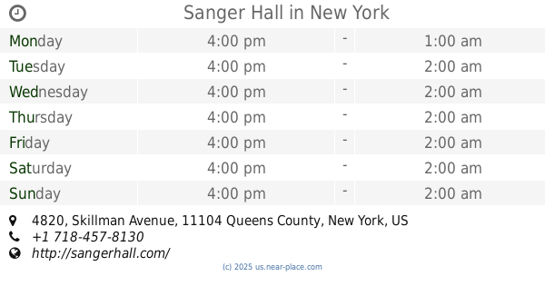
Sanger Hall
4820 Skillman Avenue, Sunnyside
Bar
read more
1.264 km
DiWine
41-15 31st Avenue, Astoria
Bar
read more
1.293 km
The Local
41-04 31st Avenue, Astoria
Bar
read more
📑
all categories
Accounting
Administrative area level 1
Administrative area level 2
Airport
Amusement park
Aquarium
Art gallery
Atm
Bakery
Bank
Bar
Beauty salon
Bicycle store
Book store
Bowling alley
Bus station
Cafe
Campground
Car dealer
Car rental
Car repair
Car wash
Casino
Cemetery
Church
City hall
Clothing store
Colloquial area
Convenience store
Courthouse
Dentist
Department store
Doctor
Electrician
Electronics store
Embassy
Establishment
Finance
Fire station
Florist
Food
Funeral home
Furniture store
Gas station
General contractor
Grocery or supermarket
Gym
Hair care
Hardware store
Health
Hindu Temple
Home goods store
Hospital
Insurance agency
Intersection
Jewelry store
Laundry
Lawyer
Library
Light rail station
Liquor store
Local government office
Locality
Locksmith
Lodging
Meal delivery
Meal takeaway
Mosque
Movie rental
Movie theater
Moving company
Museum
Natural feature
Neighborhood
Night club
Painter
Park
Parking
Pet store
Pharmacy
Physiotherapist
Place of worship
Plumber
Point of interest
Police
Political
Post office
Premise
Real estate agency
Restaurant
Roofing contractor
Route
Rv park, camping
School
Shoe store
Shopping mall
Spa
Stadium
Storage
Store
Subpremise
Subway station
Supermarket
Synagogue
Taxi stand
Train station
Transit station
Travel agency
University
Veterinary care
Zoo
administrative area level 3
sublocality level 1
↑