Bar nearby El Sancho
Coronavirus disease (COVID-19) Situation
confirmed cases
111820082
deaths
1219487
United States
Bar nearby El Sancho
El Sancho
7130, Roosevelt Avenue, 11372, Queens County, New York, US Соединенные Штаты Америки
contacts phone
:
+1 718-505-2434
Latitude:
40.7464804
, Longitude:
-73.8937236
larger map & directions
read more
nearest Bar
160 m
Chulitas
6916 Roosevelt Avenue, Woodside
Bar
read more
180 m
Scorpion Bar
6908 Roosevelt Avenue, Jackson Heights
Bar
read more
254 m
Ready Penny Inn
3707 73rd Street, Jackson Heights
Bar
read more
339 m
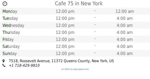
Cafe 75
7518 Roosevelt Avenue, Jackson Heights
Bar
read more
393 m
Tio Beto
41-52 70th Street, Flushing
Bar
read more
472 m
Fizz Lounge Inc
6904 Woodside Avenue, Woodside
Bar
read more
493 m
La Fonda Bar
64-09 Roosevelt Avenue, Woodside
Bar
read more
537 m
Capo Bar
78-1 Roosevelt Avenue, Jackson Heights
Bar
read more
559 m
Pata Paplean
76-21 Woodside Avenue, Elmhurst
Bar
read more
584 m
Kitchen 79
37-70 79th Street, Jackson Heights
Bar
read more
611 m
El Abuelo Pachanguero
39-08 63rd Street, Flushing
Bar
read more
617 m
El Abuelo Gozon
79-03 Roosevelt Avenue, Jackson Heights
Bar
read more
629 m
Melao
7905 Roosevelt Avenue, Jackson Heights
Bar
read more
636 m
Natalia's Bar
6210 39th Avenue, Flushing
Bar
read more
656 m
Bar Los Recuerdos
79-15 Roosevelt Avenue, Flushing
Bar
read more
687 m
Billar
69-10 34th Avenue, Woodside
Bar
read more
687 m
BQE Billiards & Bar
70-02 34th Avenue, Jackson Heights
Bar
read more
753 m
Galaxy Lounge
69-20 Queens Boulevard, Woodside
Bar
read more
829 m
Station Bar
39-50 61st Street, Woodside
Bar
read more
854 m
Cuckoo's Nest
6104 Woodside Avenue, Flushing
Bar
read more
888 m
El Gato Verde Sport Bar
82-14 Roosevelt Avenue, Queens
Bar
read more
895 m
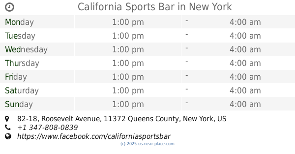
California Sports Bar
82-18 Roosevelt Avenue, Jackson Heights
Bar
read more
911 m
Sean Og's
60-02 Woodside Avenue, Woodside
Bar
read more
985 m
Barriles
83-14 37th Avenue, Jackson Heights
Bar
read more
993 m
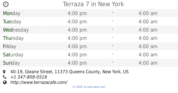
Terraza 7
40-19 Gleane Street, Queens
Bar
read more
📑
all categories
Accounting
Administrative area level 1
Administrative area level 2
Airport
Amusement park
Aquarium
Art gallery
Atm
Bakery
Bank
Bar
Beauty salon
Bicycle store
Book store
Bowling alley
Bus station
Cafe
Campground
Car dealer
Car rental
Car repair
Car wash
Casino
Cemetery
Church
City hall
Clothing store
Colloquial area
Convenience store
Courthouse
Dentist
Department store
Doctor
Electrician
Electronics store
Embassy
Establishment
Finance
Fire station
Florist
Food
Funeral home
Furniture store
Gas station
General contractor
Grocery or supermarket
Gym
Hair care
Hardware store
Health
Hindu Temple
Home goods store
Hospital
Insurance agency
Intersection
Jewelry store
Laundry
Lawyer
Library
Light rail station
Liquor store
Local government office
Locality
Locksmith
Lodging
Meal delivery
Meal takeaway
Mosque
Movie rental
Movie theater
Moving company
Museum
Natural feature
Neighborhood
Night club
Painter
Park
Parking
Pet store
Pharmacy
Physiotherapist
Place of worship
Plumber
Point of interest
Police
Political
Post office
Premise
Real estate agency
Restaurant
Roofing contractor
Route
Rv park, camping
School
Shoe store
Shopping mall
Spa
Stadium
Storage
Store
Subpremise
Subway station
Supermarket
Synagogue
Taxi stand
Train station
Transit station
Travel agency
University
Veterinary care
Zoo
administrative area level 3
sublocality level 1
↑