Bar nearby Doris
Coronavirus disease (COVID-19) Situation
confirmed cases
111820082
deaths
1219487
United States
Bar nearby Doris
Doris
1088, Fulton Street, 11238, Kings County, New York, US Соединенные Штаты Америки
contacts phone
:
+1 347-240-3350
website:
www.facebook.com
Latitude:
40.6812455
, Longitude:
-73.9573944
larger map & directions
read more
nearest Bar
201 m
Diamond Reef
2902, 1057 Atlantic Avenue, Brooklyn
Bar
read more
337 m
Dean Cafe Bar
951 Dean Street, Brooklyn
Bar
read more
337 m
B Hive Lounge
990 Atlantic Avenue, Brooklyn
Bar
read more
360 m
Hartley's
14 Putnam Avenue, Brooklyn
Bar
read more
365 m
Bad Seed Brooklyn
2936, 585 Franklin Avenue, Brooklyn
Bar
read more
369 m
Fulton Grand
1011 Fulton Street, Brooklyn
Bar
read more
407 m
Basquiat's Bottle
1198 Fulton Street, Brooklyn
Bar
read more
490 m
Buka
946 Fulton Street, New York
Bar
read more
625 m
Seven – Restaurant & Bar
470 Nostrand Avenue, Brooklyn
Bar
read more
629 m
Art Cafe + Bar
884 Pacific Street, Brooklyn
Bar
read more
629 m
Latino Sports Club
665 Franklin Avenue, Brooklyn
Bar
read more
636 m
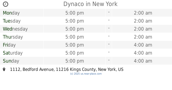
Dynaco
1112 Bedford Avenue, Brooklyn
Bar
read more
691 m
Bearded Lady
686 Washington Avenue A, Brooklyn
Bar
read more
708 m
The Way Station
683 Washington Avenue, Brooklyn
Bar
read more
824 m
Washington Commons
748 Washington Avenue, Brooklyn
Bar
read more
871 m
King Tai
1095 Bergen Street, Brooklyn
Bar
read more
883 m
Heights Bar & Grill
766 Classon Avenue, Brooklyn
Bar
read more
884 m
Baby Jane Bar
899 Fulton Street, Brooklyn
Bar
read more
920 m
Branded Saloon
603 Vanderbilt Avenue, Brooklyn
Bar
read more
936 m
Fancy Nancy
1038 Bedford Avenue, Brooklyn
Bar
read more
949 m
The Vanderbilt
570 Vanderbilt Avenue, Brooklyn
Bar
read more
978 m
Cpt. Dan's Good Time Tavern
497 Greene Avenue, Brooklyn
Bar
read more
996 m
Franklin Park
618 Saint Johns Place, Brooklyn
Bar
read more
1.029 km
Eva Jean's
30 Kosciuszko Street, Brooklyn
Bar
read more
1.34 km
The Great Georgiana
248 Dekalb Avenue, Brooklyn
Bar
read more
📑
all categories
Accounting
Administrative area level 1
Administrative area level 2
Airport
Amusement park
Aquarium
Art gallery
Atm
Bakery
Bank
Bar
Beauty salon
Bicycle store
Book store
Bowling alley
Bus station
Cafe
Campground
Car dealer
Car rental
Car repair
Car wash
Casino
Cemetery
Church
City hall
Clothing store
Colloquial area
Convenience store
Courthouse
Dentist
Department store
Doctor
Electrician
Electronics store
Embassy
Establishment
Finance
Fire station
Florist
Food
Funeral home
Furniture store
Gas station
General contractor
Grocery or supermarket
Gym
Hair care
Hardware store
Health
Hindu Temple
Home goods store
Hospital
Insurance agency
Intersection
Jewelry store
Laundry
Lawyer
Library
Light rail station
Liquor store
Local government office
Locality
Locksmith
Lodging
Meal delivery
Meal takeaway
Mosque
Movie rental
Movie theater
Moving company
Museum
Natural feature
Neighborhood
Night club
Painter
Park
Parking
Pet store
Pharmacy
Physiotherapist
Place of worship
Plumber
Point of interest
Police
Political
Post office
Premise
Real estate agency
Restaurant
Roofing contractor
Route
Rv park, camping
School
Shoe store
Shopping mall
Spa
Stadium
Storage
Store
Subpremise
Subway station
Supermarket
Synagogue
Taxi stand
Train station
Transit station
Travel agency
University
Veterinary care
Zoo
administrative area level 3
sublocality level 1
↑