Bar nearby Curio Bar
Coronavirus disease (COVID-19) Situation
confirmed cases
111820082
deaths
1219487
United States
Bar nearby Curio Bar
Curio Bar
2669 Larimer Street, Denver Stany Zjednoczone
contacts phone
:
+1
Latitude:
39.7593608
, Longitude:
-104.9846129
read more
nearest Bar
56 m
Meadowlark Bar
2701 Larimer Street, Denver
Bar
read more
88 m
First Draft Taproom & Kitchen
1309 26th Street, Denver
Bar
read more
225 m
Our Mutual Friend Brewing
2810 Larimer Street, Denver
Bar
read more
245 m
Work & Class
2500 Larimer Street, Denver
Bar
read more
387 m
Bierstadt Lagerhaus
2875 Blake Street, Denver
Bar
read more
456 m
The Block Distilling Co.
2990 Larimer Street, Denver
Bar
read more
693 m
3 Hundred Days Distilling Tasting Room
2201 Larimer Street, Denver
Bar
read more
693 m
Whiskey Room
2201 Larimer Street, Denver
Bar
read more
719 m
The Walnut Room
3131 Walnut Street, Denver
Bar
read more
755 m
The Populist
3163 Larimer Street, Denver
Bar
read more
756 m
Star Bar
2137 Larimer Street, Denver
Bar
read more
761 m
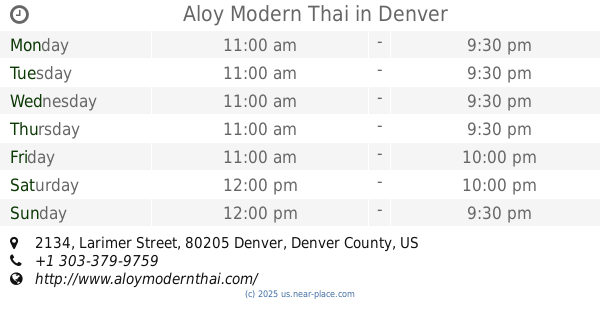
Aloy Modern Thai
2017, 2134 Larimer Street, Denver
Bar
read more
766 m
Marco's Coal Fired Pizzeria | Ballpark
2129 Larimer Street, Denver
Bar
read more
767 m
Goed Zuur
2801 Welton Street, Denver
Bar
read more
809 m
Aramark
2151 Blake Street, Denver
Bar
read more
809 m
Mountain Ranch Bar and Grille at Coors Field
2151 Blake Street, Denver
Bar
read more
832 m
Improper City
2328, 3201 Walnut Street, Denver
Bar
read more
901 m
The Curtis Club
2100 Curtis Street, Denver
Bar
read more
918 m
Scruffy Murphy's
2030 Larimer Street, Denver
Bar
read more
939 m
Escapology Denver
2220 California Street #100, Denver
Bar
read more
1.057 km
Roo Bar
3480 Park Avenue West, Denver
Bar
read more
1.061 km
Swanky's Vittles & Libations
1230, 1938 Blake Street, Denver
Bar
read more
1.078 km
sports column
1930 Blake Street, Denver
Bar
read more
1.09 km
Tap Fourteen - Rooftop Beer Garden
1920 Blake Street, Denver
Bar
read more
1.267 km
The Old Spaghetti Factory
1215 18th Street, Denver
Bar
read more
📑
all categories
Accounting
Administrative area level 1
Administrative area level 2
Airport
Amusement park
Aquarium
Art gallery
Atm
Bakery
Bank
Bar
Beauty salon
Bicycle store
Book store
Bowling alley
Bus station
Cafe
Campground
Car dealer
Car rental
Car repair
Car wash
Casino
Cemetery
Church
City hall
Clothing store
Colloquial area
Convenience store
Courthouse
Dentist
Department store
Doctor
Electrician
Electronics store
Embassy
Establishment
Finance
Fire station
Florist
Food
Funeral home
Furniture store
Gas station
General contractor
Grocery or supermarket
Gym
Hair care
Hardware store
Health
Hindu Temple
Home goods store
Hospital
Insurance agency
Intersection
Jewelry store
Laundry
Lawyer
Library
Light rail station
Liquor store
Local government office
Locality
Locksmith
Lodging
Meal delivery
Meal takeaway
Mosque
Movie rental
Movie theater
Moving company
Museum
Natural feature
Neighborhood
Night club
Painter
Park
Parking
Pet store
Pharmacy
Physiotherapist
Place of worship
Plumber
Point of interest
Police
Political
Post office
Premise
Real estate agency
Restaurant
Roofing contractor
Route
Rv park, camping
School
Shoe store
Shopping mall
Spa
Stadium
Storage
Store
Subpremise
Subway station
Supermarket
Synagogue
Taxi stand
Train station
Transit station
Travel agency
University
Veterinary care
Zoo
administrative area level 3
sublocality level 1
↑