Bakery nearby Insomnia Cookies
Coronavirus disease (COVID-19) Situation
confirmed cases
111820082
deaths
1219487
United States
Bakery nearby Insomnia Cookies
Insomnia Cookies
116 Macdougal Street, New York United States
contacts phone
:
+1
Latitude:
40.7297645
, Longitude:
-74.0005774
read more
nearest Bakery
141 m
Li-Lac Chocolates (Greenwich Village)
162 Bleecker Street, New York
Bakery
read more
172 m
Fay Da Bakery
321 6th Avenue, New York
Bakery
read more
243 m
Amy's Bread
250 Bleecker Street, New York
Bakery
read more
424 m
Daily Bread
200 Varick Street # E, New York
Bakery
read more
480 m
Hudson Bagels
82 Christopher Street, New York
Bakery
read more
499 m
Maison Kayser
326 Bleecker Street, New York
Bakery
read more
534 m
IL Cantuccio
91 Christopher Street, New York
Bakery
read more
550 m
Dominique Ansel Bakery
189 Spring Street, New York
Bakery
read more
571 m
Dominique Ansel Kitchen
137 Seventh Avenue South, New York
Bakery
read more
588 m
Mah-Ze-Dahr Bakery
28 Greenwich Avenue, New York
Bakery
read more
628 m
Lafayette
380 Lafayette Street, New York
Bakery
read more
638 m
Bagel Bob's
51 University Place, New York
Bakery
read more
668 m
Georgetown Cupcake
111 Mercer Street, New York
Bakery
read more
687 m
Agata & Valentina
64 University Place, New York
Bakery
read more
717 m
Sweet Corner Bakeshop
535 Hudson Street, New York
Bakery
read more
735 m
The Warm Oven
123 6th Avenue, New York
Bakery
read more
835 m
Parisi Bakery
290 Elizabeth Street, New York
Bakery
read more
877 m
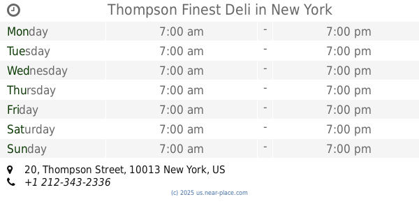
Thompson Finest Deli
20 Thompson Street, New York
Bakery
read more
886 m
Dunkin Donuts
2 West 14th Street, New York
Bakery
read more
948 m
Morris Philip
120 Park Ave # 6, New York
Bakery
read more
965 m
Pan Ya
8 Stuyvesant Street, New York
Bakery
read more
983 m
Spot Dessert Bar
13 Saint Marks Place, New York
Bakery
read more
1.034 km
Tribeca Bagels
2206, 374 Canal Street, New York
Bakery
read more
1.112 km
Rohnda Bakes
West 17th Street, New York
Bakery
read more
1.146 km
Yonah Schimmel Knish Bakery
137 East Houston Street, New York
Bakery
read more
📑
all categories
Accounting
Administrative area level 1
Administrative area level 2
Airport
Amusement park
Aquarium
Art gallery
Atm
Bakery
Bank
Bar
Beauty salon
Bicycle store
Book store
Bowling alley
Bus station
Cafe
Campground
Car dealer
Car rental
Car repair
Car wash
Casino
Cemetery
Church
City hall
Clothing store
Colloquial area
Convenience store
Courthouse
Dentist
Department store
Doctor
Electrician
Electronics store
Embassy
Establishment
Finance
Fire station
Florist
Food
Funeral home
Furniture store
Gas station
General contractor
Grocery or supermarket
Gym
Hair care
Hardware store
Health
Hindu Temple
Home goods store
Hospital
Insurance agency
Intersection
Jewelry store
Laundry
Lawyer
Library
Light rail station
Liquor store
Local government office
Locality
Locksmith
Lodging
Meal delivery
Meal takeaway
Mosque
Movie rental
Movie theater
Moving company
Museum
Natural feature
Neighborhood
Night club
Painter
Park
Parking
Pet store
Pharmacy
Physiotherapist
Place of worship
Plumber
Point of interest
Police
Political
Post office
Premise
Real estate agency
Restaurant
Roofing contractor
Route
Rv park, camping
School
Shoe store
Shopping mall
Spa
Stadium
Storage
Store
Subpremise
Subway station
Supermarket
Synagogue
Taxi stand
Train station
Transit station
Travel agency
University
Veterinary care
Zoo
administrative area level 3
sublocality level 1
↑