Airport nearby Rides2 airports
Coronavirus disease (COVID-19) Situation
confirmed cases
111820082
deaths
1219487
United States
Airport nearby Rides2 airports
Rides2 airports
22, Flax Hill Road, 06854, Norwalk, Fairfield County, US Соединенные Штаты Америки
contacts phone
:
+1 203-554-1416
website:
facebook.com
Latitude:
41.099904
, Longitude:
-73.422913
larger map & directions
read more
nearest Airport
212 m
50 Washington Street Heliport
Norwalk
Airport
read more
3.289 km
Norden Systems Heliport
Norwalk
Airport
read more
4.983 km
Merritt 7 Helistop
20 Glover Avenue, Norwalk
Airport
read more
5.038 km
The Towers
901 Main Avenue, Norwalk
Airport
read more
5.809 km
USSC Heliport
150 Glover Avenue, Norwalk
Airport
read more
11.059 km
Canal Street
737 Canal Street #16, Stamford
Airport
read more
11.946 km
Stamford Hospital Heliport
Stamford
Airport
read more
23.733 km
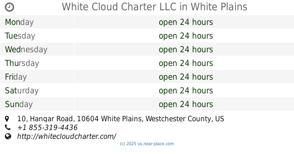
White Cloud Charter LLC
10 Hangar Road Hangar G, White Plains
Airport
read more
23.765 km
Duncan Aviation Inc
2 Hangar Road # 1, White Plains
Airport
read more
23.787 km
Signature Flight Support HPN East - White Plains Westchester County Airport
2 Hangar Road, White Plains
Airport
read more
24.006 km
Huntington Emergency Helistop
Huntington
Airport
read more
24.068 km
Pepsi
150 Airport Road, White Plains
Airport
read more
24.202 km
Аэропорт Уэстчестер
240 Airport Road, White Plains
Airport
read more
24.423 km
Zip Aviation
136 Tower Rd, Hangar M, White Plains
Airport
read more
24.425 km
Safe Flight Instrument Corporation Heliport
White Plains
Airport
read more
24.536 km
Old Orchard Road Heliport
Armonk
Airport
read more
24.567 km
Signature Flight Support HPN West - White Plains Westchester County Airport
85 Tower Road, White Plains
Airport
read more
24.77 km
Ross Aviation - White Plains West (HPN)
67 Tower Road, West Harrison
Airport
read more
25.087 km
VAMC Heliport
Northport
Airport
read more
26.869 km
Harris Hill Heliport
Bedford Hills
Airport
read more
32.314 km
IBM Somers Heliport
294 ROUTE 100, Somers
Airport
read more
43.987 km
Long Island MacArthur Airport
100 Arrival Avenue, Ronkonkoma
Airport
read more
49.195 km
Belmont Park Heliport
Elmont
Airport
read more
52.119 km
West Jet
Terminal C, 1, LaGuardia Road, Flushing
Airport
read more
52.631 km
American Airlines Federal Credit Union
Flushing
Airport
read more
📑
all categories
Accounting
Administrative area level 1
Administrative area level 2
Airport
Amusement park
Aquarium
Art gallery
Atm
Bakery
Bank
Bar
Beauty salon
Bicycle store
Book store
Bowling alley
Bus station
Cafe
Campground
Car dealer
Car rental
Car repair
Car wash
Casino
Cemetery
Church
City hall
Clothing store
Colloquial area
Convenience store
Courthouse
Dentist
Department store
Doctor
Electrician
Electronics store
Embassy
Establishment
Finance
Fire station
Florist
Food
Funeral home
Furniture store
Gas station
General contractor
Grocery or supermarket
Gym
Hair care
Hardware store
Health
Hindu Temple
Home goods store
Hospital
Insurance agency
Intersection
Jewelry store
Laundry
Lawyer
Library
Light rail station
Liquor store
Local government office
Locality
Locksmith
Lodging
Meal delivery
Meal takeaway
Mosque
Movie rental
Movie theater
Moving company
Museum
Natural feature
Neighborhood
Night club
Painter
Park
Parking
Pet store
Pharmacy
Physiotherapist
Place of worship
Plumber
Point of interest
Police
Political
Post office
Premise
Real estate agency
Restaurant
Roofing contractor
Route
Rv park, camping
School
Shoe store
Shopping mall
Spa
Stadium
Storage
Store
Subpremise
Subway station
Supermarket
Synagogue
Taxi stand
Train station
Transit station
Travel agency
University
Veterinary care
Zoo
administrative area level 3
sublocality level 1
↑